Kaname Forest (Yamagata)
Mitsui's Forests
Nationally Certified Sustainably Managed Natural Sites
We will broadly communicate the multifaceted natural-capital value of “Mitsui's Forests” through the domestic and international frameworks of “Nationally Certified Sustainably Managed Natural Sites” and OECMs.
Through these initiatives, we will maintain and enhance forest functions through sustainable forest management, contributing to the enhancement of Japan's forest value and the realization of a nature-positive society.
- What Is a Nationally Certified Sustainably Managed Natural Site?
- Policy on Nationally Certified Sustainably Managed Natural Site Registration
- Organizing the Value of Our Forests by the Nine Value Criteria of Nationally Certified Sustainably Managed Natural Sites
- Details of Forests Registered as Nationally Certified Sustainably Managed Natural Sites
What Is a Nationally Certified Sustainably Managed Natural Site?

A “Nationally Certified Sustainably Managed Natural Site” is an area, outside of protected areas such as national parks, where biodiversity is being conserved through private-sector and other initiatives and which the national government certifies. Among certified areas, those that do not overlap with existing protected areas are registered in international databases as OECMs (Other Effective area-based Conservation Measures) (*), further contributing to the achievement of Japan's “30by30 target.” This is a common global goal to effectively conserve at least 30% of land and sea as healthy ecosystems by 2030. At Nationally Certified Sustainably Managed Natural Sites, the value of the target area is evaluated against nine value criteria, including biodiversity, ecosystem services, rare species, regional culture, and continuity with existing protected areas. At Mitsui's Forests, we organize the characteristics of our company-owned forests nationwide based on these international value criteria, making the diverse values that forests possess visible.
* OECM: refers to areas that are not protected areas such as national parks but that contribute to the conservation of biodiversity.
Mitsui's Policy on Nationally Certified Sustainably Managed Natural Site Registration
For Mitsui, registration as a Nationally Certified Sustainably Managed Natural Site / OECM is not merely the acquisition of a certification. It is an initiative that demonstrates, within an internationally shareable framework, the multifaceted natural-capital value of forests—including biodiversity, ecosystem services, and connections with regional culture—in addition to conventional forest functions such as timber production and the absorption and fixation of carbon dioxide. At “Mitsui's Forests” nationwide, we have obtained FSC® certification, an international forest certification (Mitsui & Co. (FM) license number: FSC® C057355), and are advancing sustainable forest management. Through registration as Nationally Certified Sustainably Managed Natural Site, we make visible the multifaceted natural-capital value of each forest—such as biodiversity, ecosystem services, and regional culture—and, while fulfilling our responsibility as a company that owns vast company-owned forests, we will lead the enhancement of Japan's forest value.
Organizing the Value of Our Forests by the Nine Value Criteria of Nationally Certified Sustainably Managed Natural Sites
Currently, five of “Mitsui‘s Forests”—the Soya Forest and Ishii Forest (both in Hokkaido), Kaname Forest (Yamagata Prefecture), Tashiro Forest (Fukushima Prefecture), and the Kiyotaki Forest (Kyoto Prefecture)— are certified as Nationally Certified Sustainably Managed Natural Sites. Each of these forests has a different natural environment and regional characteristics, and they are recognized as initiatives that broadly satisfy the nine value criteria of Nationally Certified Sustainably Managed Natural Sites , including biodiversity, ecosystem services, rare species, cultural value, and continuity with existing protected areas. We will continue appropriate forest management that leverages the characteristics of each forest, and communicate the diverse values that forests provide to society at home and abroad.
Please scroll horizontally to look at table below.
| Forest Name | Location | Area | Value Criteria | ||||||||
|---|---|---|---|---|---|---|---|---|---|---|---|
| (1) Existing Protected Areas |
(2) Pristine Natural Ecosystem |
(3) Secondary Natural Environment / Ecosystem |
(4) Ecosystem Services |
(5) Cultural Significance |
(6) Rare Species |
(7) Distribution of Endemic / Regionally-limited Species |
(8) Importance for Animal Life Cycles |
(9) Connectivity / Buffer Function with Existing Protected Areas |
|||
| Soya | Hokkaido | 484.43ha | Hucho perryi (Japanese huchen) habitat | Hucho perryi (Japanese huchen) habitat | |||||||
| Ishii | Hokkaido | 308.26ha | Non-clearcut / retention forestry | Diverse ecosystem services | |||||||
| Kaname | Yamagata | 699.17ha | Beech primeval forest | ||||||||
| Tashiro | Fukushima | 999.13ha | Oze National Park | High moor plant growth habitat | National park connectivity zone | ||||||
| Kiyotaki | Kyoto | 188.25ha | Ecosystem composed of native species | Contribution to traditional Kyoto events | |||||||
Details of Forests Registered as Nationally Certified Sustainably Managed Natural Sites
Soya Forest
| Registration period | Second half of 2025 |
|---|---|
| Location & Area | Hokkaido, 484.43 ha (the environmental protection forest portion of the 1,960 ha Soya Forest) |
| Site overview | Located in Sarufutsu Village, Soya District, Hokkaido, this forest spreads across several river basins, including the Sarukotsu and Ekope rivers. Consisting mainly of natural and naturally regenerated forests of Sakhalin fir and Sakhalin spruce, it plays an important role as a habitat and feeding ground for rare fish and birds. |
| Information on the Ministry of the Environment Visualization Map | To be posted on the Ministry of the Environment website (in preparation) |
Value (6): A place where rare animal and plant species live or grow, or where there is a high possibility of such
In the Sarukotsu River flowing through the site, the Sakhalin taimen—Japan's largest freshwater fish—and the cherry salmon (yamame), a species of note, have been confirmed. The freshwater pearl mussel has also been confirmed in the same water system, and white-tailed eagles and Steller's sea eagles flying over the site have likewise been confirmed.
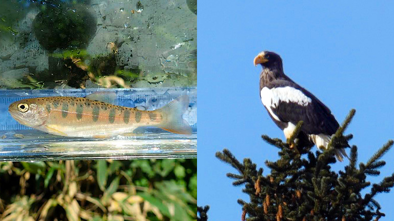
Left:Cherry salmon (yamame) Right:Steller's sea eagle
Value (8): A place important to the life history of animals, such as for overwintering, resting, breeding, foraging, and migration
In the Sarukotsu River flowing through the site, the upstream migration and spawning of the Sakhalin taimen, Japan's largest freshwater fish, have been confirmed. Foraging traces of birds such as the white-tailed eagle have also been confirmed in the same water system, making it an important place for the breeding of fish such as the Sakhalin taimen and the foraging of birds such as the white-tailed eagle.
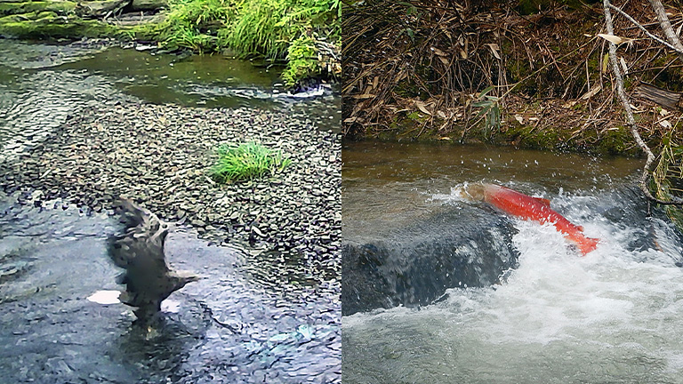
Left:White-tailed eagle Right: Sakhalin taimen
Ishii Forest
| Registration period | 2025 (latter half) |
|---|---|
| Location & Area | Tokachi District, Hokkaido; 308.26ha (entire forest area) |
| Site overview | Located in Tokachi District, Hokkaido, this is a multi-layered mixed conifer-broadleaf forest where broadleaf trees such as Mongolian oak, naturally regenerated within planted forests of Japanese larch and Sakhalin fir, grow. Large-diameter Japanese larch trees planted in 1926 (the first year of the Showa era) still remain, and rare flora and fauna such as Japanese primrose, black woodpecker, and Siberian flying squirrel have also been confirmed. |
| Ministry of the Environment Visualization Map listing | To be posted on the Ministry of the Environment website (in preparation) |
Value (3): A place with an ecosystem characteristic of secondary natural environments such as satoyama landscapes
Because the previous owner actively retained superior broadleaf trees, the Ishii Forest is a mixed coniferous-broadleaf forest in which Mongolian oak and other broadleaf trees have naturally regenerated within a Japanese larch plantation, and in some places natural regeneration has been achieved within the planted forest. Seventy-six large-diameter Japanese larch trees planted in 1926—old even among Hokkaido's planted larch forests—still remain. Many naturally regenerated, aged broadleaf trees are also seen, forming a landscape distinctive even among planted forests.
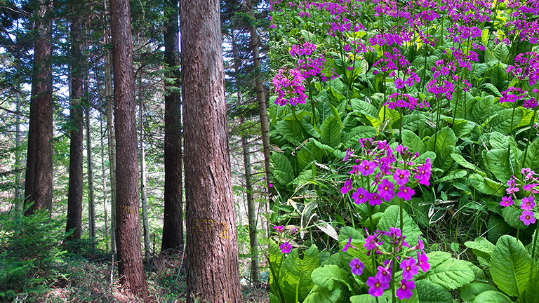
Left:Around the old-generation Japanese larch Right:Japanese primrose
Value (4): A place that provides ecosystem services and has a healthy ecosystem composed of diverse flora and fauna centered on native species
The Ishii Forest is managed appropriately based on zoning, forming an environment in which diverse species live even within a planted forest. The results of LEAP analysis also showed favorable figures for soil-runoff control, stored carbon volume, and the like.
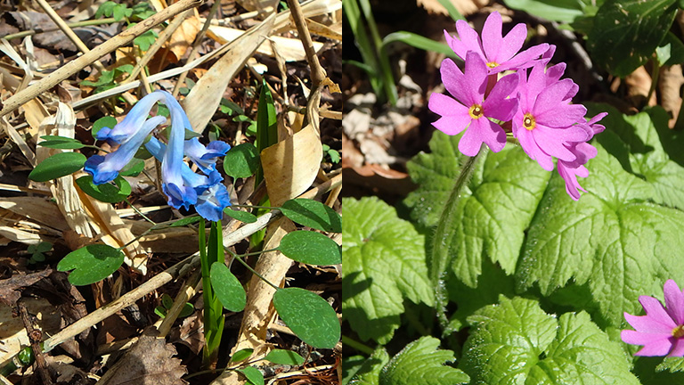
Left:Corydalis ambigua Right:Hokkaido primrose (Primula jesoana)
Kaname Forest
| Registration period | Second half of 2024 |
|---|---|
| Location & Area | Yamagata Prefecture, 699.17 ha (entire forest) |
| Site overview | Near the Asahi mountain range in Bandai-Asahi National Park, this is a forest of broadleaf trees dominated by Japanese beech. It forms part of the natural forest known as the “White Forest” in Oguni Town and nurtures a rich ecosystem. |
| Information on the Ministry of the Environment Visualization Map | https://policies.env.go.jp/nature/biodiversity/30by30alliance/documents/nintei/R6second11_MitsuisForestsKanameForest.pdf |
Value (2): A place with a primeval natural ecosystem
Value (4): A place that provides ecosystem services and has a healthy ecosystem composed of diverse animal species centered on native species
Broadleaf forests dominated by beech account for most of the area, forming the “White Forest” together with adjacent forests. With steep terrain and almost no human intervention, it is an area where rich ecosystems exist, serving as a range of activity for “matagi” (traditional hunters). As rare species, the Japanese serow (a nationally designated special natural monument) and, in the water system, the forest green tree frog have been confirmed.
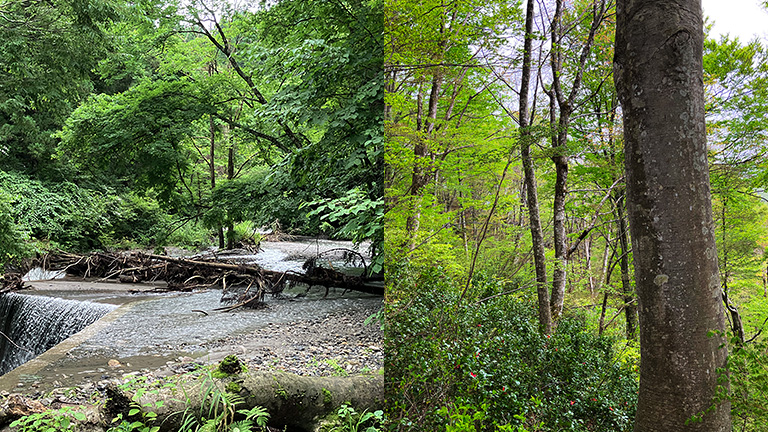
Left:Erosion-control dam Right:Beech-dominated broadleaf forest
Main flora and fauna confirmed
Plants: Japanese clethra, false daphne, Iwauchiwa, Japanese camellia (Yukitsubaki), rowan, kobushi magnolia, Siebold's maple, spicebush, Japanese white pine, linden viburnum, Viburnum furcatum, Japanese bird cherry, Japanese winterberry, Japanese ash, Miyako bamboo grass, Murasakiyashio azalea, Japanese walnut
Animals: sika deer, Japanese wild boar, Asian black bear, Japanese serow, forest green tree frog, Japanese fire belly newt
Insects: Japanese tortoiseshell butterfly (adult)
Birds: Japanese tit, brown-eared bulbul, Eurasian jay
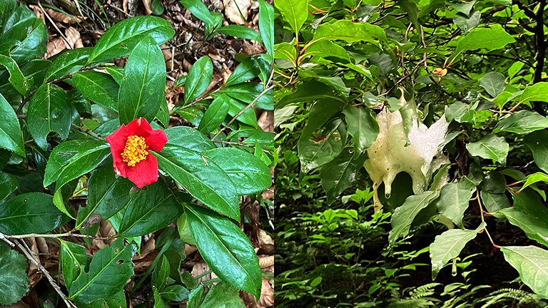
Left:Japanese camellia (Yukitsubaki) Right:Egg mass of the forest green tree frog
Tashiro Forest
| Registration period | Second half of 2025 |
|---|---|
| Location & Area | Fukushima Prefecture, 999.133 ha (entire forest) |
| Site overview | This forest occupies part of Mt. Tashiro, located in Minamiaizu Town, Minamiaizu District, Fukushima Prefecture. A plateau-like raised bog spreads across the summit, where diverse alpine plants can be seen through the seasons, including alpine avens (chinguruma), Schizocodon soldanelloides (iwakagami), Gentiana thunbergii (tateyama-rindo), and cotton grass (watasuge). |
| Information on the Ministry of the Environment Visualization Map | To be posted on the Ministry of the Environment website (in preparation) |
Value (1): A place where importance for biodiversity conservation has already been recognized by a public institution
Oze National Park was designated in 1934 as part of Nikko National Park, but in 2007 the Oze area was separated and, incorporating the surrounding area including Mt. Tashiro, was designated as the 29th national park. The Oze area is based on mountainous terrain formed by eruptions of the Oze volcanic group, and features Honshu's largest mountain moor surrounded by mountains, moor vegetation shaped by terrain and climate, riparian forests, and flower fields. The northern area around Mt. Aizu-Komagatake and the eastern and southern areas around Mt. Kinunuma, Mt. Taishaku, and Mt. Tashiro also have forest zones dominated by beech and Maries' fir and moist grasslands at the summits, showing generally highly common vegetation.
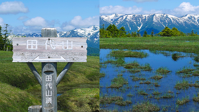
Left:Summit signboard Right:Summit moor pond in early summer
Value (7): A place where species with ecological particularities—such as limited distribution or dependence on a peculiar environment—live or grow, or where there is a high possibility of such
Mt. Tashiro, included in the Tashiro Forest, has a moor spreading across its plateau-like summit, where alpine plants such as nikko day lily, Sieversia pentapetala, Iwakagami, dwarf rhododendron, and cotton grass can be seen. The moor's elevation is about 1,920–1,970 m; with little undulation, it is a moor gently sloping toward the northeast.
Value (9): A place that has buffering functions or enhances continuity and connectivity, such as by adjoining or connecting existing protected areas or designated Nature Coexistence Site areas
The Tashiro Moor, included in the Tashiro Forest, is part of Oze National Park and is designated as a special protection area. The subalpine zone continuous with the national park area is designated as a Class 2 special protection zone, where conifers such as Maries' fir, Japanese arborvitae, and Japanese stone pine grow.
Kiyotaki Forest
| Registration period | Second half of 2023 |
|---|---|
| Location & Area | Kyoto Prefecture, 188.25 ha (entire forest) |
| Site overview | Located in a corner of the Kitayama forestry district, famous for its polished logs (migaki-maruta), this is a forest consisting mainly of Japanese cedar (sugi), Japanese cypress (hinoki), and Japanese red pine (akamatsu). The forest is managed in accordance with the distinct characteristics of each area: naturally regenerated managed forests, general natural forests, and culturally protected forests. |
| Information on the Ministry of the Environment Visualization Map | https://policies.env.go.jp/nature/biodiversity/30by30alliance/documents/nintei/R5second46_MitsuiFudosanNoMori_KiyotakiForest.pdf |
Value (3): A place with an ecosystem characteristic of secondary natural environments such as satoyama landscapes
In the planted forests centered on Japanese red pine, cedar, and cypress, we secure wide spacing between tree trunks and encourage the natural emergence of miscellaneous trees, guiding them toward mixed coniferous-broadleaf forests. In the general naturally regenerated forests of broadleaf trees, we carry out felling, weeding, and vine-cutting to enhance the forests' public-benefit value. In some areas, we maintain afforestation land for the polished logs that are a feature of Kitayama forestry. Native animals such as the Japanese green woodpecker, blue-and-white flycatcher, weasel, marten, and squirrel have been confirmed.
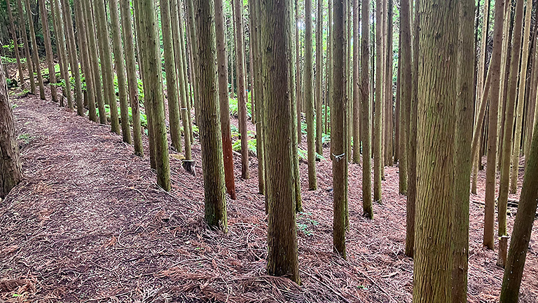
Cedar afforestation land for polished logs
Value (5): Value as a place supplying natural resources used for regional traditional culture, such as traditional crafts and traditional events
We have concluded an agreement with the Kyoto Model Forest Association and lend approximately 19 hectares of cultural conservation forest free of charge. We provide Japanese red pine and Rhododendron reticulatum as firewood and torches used in the traditional events “Gozan Okuribi” and “Kurama Fire Festival.” Before the COVID-19 pandemic, the area was also used for forest-experience learning such as thinning, and as a place for local residents to experience forest-making.
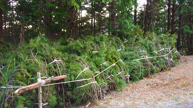
Pine needles for the “Gozan Okuribi”