The Mitsui & Co. Environment Fund
Introduction to Grant Projects
Kyoto University Graduate Schol of Science, Associate Professor, Shoichi Shige
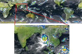
Creation and evaluation of a global precipitation map using satellite data
Research grant
- Project Description
Research on the distribution of global precipitation and its changes are essential for clarifying the causal relation with climate change, establishing a water circulation model, conserving water resources, maintaining an ecological environment and predicting agricultural productivity. As a result, it is important to create a global precipitation map based on reliable observations, which utilizes data from satellites. This purpose of this research is to create a global precipitation map over 3 years using a microwave radiometre equipped man-made satellite and infrared radiation data in order to evaluate this research under an international collaborative research framework. Our assessment will also include the evaluation of precipitation maps created by each country's research team participating in the IPWG/PEHRPP (an organization sponsored by the World Meteorological Organization). This research consists of cooperation between five organisations; Kyoto University, Osaka University, Tottori University of Environmental Studies, Japan Aerospace Exploration Agency(JAXA) and the National Institute of Information and Communications Technology.
- Fields
- Climate change
- Grant year
- FY2007 Research Grants
- Grant term
- 3 years
April 2008 - March 2011
- Grant amount
- 14,404,740 yen
- Activity region
- Earth (particularly tropical and subtropical zones)
Overview of the Organization

- Representative
- Associate Professor, Shoichi Shige
- Profile
- Specialist field
Meteorology, climatology earth observation. Research related to the estimation of latent heat and precipitation using man-made satellite data
Affiliated academic societies
The Meteorological Society of Japan, American Meteorological Society, American Geophysical Union, The Remote Sensing Society of Japan, IEEE Geoscience society and remote sensing society
Background
Graduated in 2001 from Kyoto University Graduate School of Science doctoral course, Joined JAXA in 2001 as a visiting research scholar. Joined Osaka Prefecture University Graduate School of Engineering College of Engineering as an assistant in 2004, and became an associate professor in 2007. Joined Kyoto University Graduate School of Science as an associate professor in 2009 as a Doctor of Science - Collaborating researchers
- Tottori University of Environmental Studies Professor Kenichi Okamoto, Osaka University Associate Professor Tomio Ushio, JAXA senior development staff Misako Kachi, JAXA reseracher Takushi Kubota, National Institute of Information and Communications Technology group leader Toshio Iguchi
- Research achievements
-
- (1) Shige, S., T. Watanabe, et al., 2008: Validation ofwestern and eastern Pacific rainfall estimates from the TRMM PR using a radiative transfer model. J. Geophys. Res., 113, D15116, doi:10.1029/2007JD009002
- (2) Shige, S., Y. N. Takayabu, et al., 2007: Spectral retrieval of latent heating profiles from TRMM PR data. Part II: Algorithm improvement and heating estimates over tropicalocean regions. J. Appl. Meteor. Climatol., 46, 1098-1124.